Showing posts with label Iceland. Show all posts

Monday, October 20, 2014

The Seljalandsfoss

Thundering water beats the pool.


One thing Iceland has enough of, is waterfalls. Spectacular waterfalls. Pretty waterfalls. I had a lot of miserable weather in Iceland, but at the Seljalandsfoss in the south east i was greeted with a sun. Creating rainbows in the water droplets thrown away from the riverbody after the fall from above.


The frontal view of the Seljalandsfoss. Foss means waterfall. It is close to (and visible from) the ringroad, meaning easy access and at times way to many visitors.

The extra surprise of the Seljalandsfoss-a trail going behind the waterfall itself.

Looking up. The fall is 60 meters tall and fall down what used to be the coastline. Now the coast in the imminent area is flat.
Most of the coast on this part of Iceland is now flat-so there has been a major shift!
A pretty and easy walk along the cliff brings you pass a couple of more waterfalls. This one, the Gljufurarfoss, being the most remarkable. It has cut itself a little canyon-it is almost like a tube. It is a fun experience to walk into it-but a wet one! And despite the proximity to the Seljalandsfoss, only a fraction of the visitors continue to this waterfall.

A section of the top of the Gljufurfoss. The water caressing a stone before letting go. There is a trail-vague in places and obviously steep in places-leading to the top.

Saturday, October 18, 2014

Jokulsarlon. The beauty of ice and frost.


Another Icelandic natural wonder. A never ending list. Jokulsarlon is a glacial lake formed when a glacier hugging the ocean retreated. The lake itself is around 1,5 kilometers away from the sea-but is connected to it via a freezing cold river. It is right beside the ring road going around the whole coast of the country and thus easy to get to. I arrived here in early spring. The weather was good-but not surprisingly cold. The Breidamerkurjokul glacier-itself part of the huge Vatnajokul is in the background pumping ice into the lake.

For a Norwegian, this place is like some sort of a time travel capsule. It shows Norway as it was when man arrived there at the end of the iceage. And its black beach of volcanic sand-highlighting why the country is nicked The Land of Ice and Fire-is totally clean-and away from the parking lot without footsteps. Giving it a form of untouched cleanness not found too many places in 2014.
A polarbear? A greyhound dog? A horse? I see them all in this floating ice sculpture slowly heading towards the sea and destruction.

It has finished its work-but it has done some serious scrubbing of the volcanic rock below the glacier. 

Some blue ice. The surface has not yet been pounded by the sun-once it does and cracks open, it turns white.

White ice, black rock. Like a piece of candy.

Not far away from the ice, life slowly takes over. a process taking generation upon generation in a climate as unforgiving as what is found here.

And even further out-established vegetation, even though it is not tall.

Not at the lake, but in the area. Warming my butt on a waterpipe leading hot water from a spring to a farming community. The land of ice and fire...

Friday, October 17, 2014

Raudanes, natural rockartistery at its best.

The best of it. I walked dơwn to a beach of basalt and rolling stones to capture the basaltcoloumn trough the big arch. Most of the beach is more or less inaccessible on foot. A boat is needed. The coastline is specked with small caves and overhangs.


Raudanes is a small peninsula some 30 kilometers from the end of the world fishing village Thorshofn, eastern Iceland. From the main road there is nothing hinting about this pearl except a sign. It is a place you will overlook if you don't already know about it.
I did two tries on this place. The first one in the spring while the access road was muddy. Big mistake. I needed the aid of the roadrescue team to get back on the mainroad. And by the time situation was under control, fog and rain had arrived.

My second and successfull attempt was in late July. Now the road was dry and hard-with some pieces of wood still embedded in the now hard mud-the monument of my unsuccessful attempt of saving face.

Raudanes is mostly heathland, but along its edges is the treasure in the form of spectacular basalt formations chiseled by the relentless ocean. There is no protection from it. Or from the howling winds.


Gluggur. Once a seacave. Now it has collapsed and left a fantastic arch on the cliffedge.


Wednesday, October 15, 2014

Dettifoss and the canyonland.


Dettifoss, one of Iceland's best known and most iconic waterfalls thunders dơwn into the Jokulsargljủfur canyon. It is 100 meters wide and 45 meters tall and one of Europe's most powerfull waterfalls. I drove there from Myvatn. First along the route 1 (the ring road), then along the road 862 dơwn to a parking lot a short hike from the waterfall itself. I arrived in mixed weather, it was generally cloudy with some rain, but with short spells of sun in between-creating small rainbows in the mist from the waterfall. There í an interesting trail going along the rim of the canyon. The most used part go upstream to the neighbouring Selfoss, pretty but small. Mỏe adventurous í the trail heading downstream on the canyon rim, At some places a bit difficult to follow, and some care must be taken for those not interested in broken legs, but in dry weather it is no problem.

A carpet of particle filled water from the glaciers upstream. Standing at the edge is a mighty experience-full of noise and a constant shower of water churned up from the fall

Overview over the Jokulargljufur canyon. I went for a few hours before returning to my vehicle. It í possible to hike all the way dơwn to Ásbyrgi in a couple of days, but i was going to drive dơwn via the bumpy gravel road on the opposite side of the canyon. Taking hikes out from Asbyrgi.

Outstanding beauty. The canyon is one of the largest in Iceland; 100 meters deep and 24 kilometers long.

What looks like a spring in the riverbed.
A special sight. Clear spring water and murky glacial water side by side in the same river.

Springwater and glacial water meets up in the Jokulsa river.

The Jokulsa meets the sea near Ábyrgi. Up along the canyon there are a handfull of interesting places. The first of them is Raudholar-a rơw of ancient craters, which, as the name suggests, are red.

Raudholar with the canyon in the background.

Red sand and black burned rock.

Thin walls of lava gets engulfed by green, healthy forest.


Hljodaklettar, a spectacular basalt formation with a special surprise hidden in it. Once inside it, the sound from the river gets reflected in a way making it almost impossible to pinpoint the true direction of the river-based on the sound.

The basalt of Hljodaklettar.


Karl and Kẻrling beside Jokulsa. Scientifically they are eroded basalt pillars. In folklore they are trolls which became stone when hit by the sun.

One of many pretty waterfalls falling towards the Jokulsa river.


Friday, September 26, 2014

The greatness of Mother Earth-Myvatn and around.


View of southern Myvatn, with islands boosting pseudocraters in it.


The Myvatn area is nothing less than a must when travelling this country. It is an area offering hot springs, geothermal vents. There are craters, lava flows and myriads of small and big formations. The area is a paradise for birds, and the lake is teeming with fish. And in sharp contrast to the rough lava-are the wildflowers, green pastureland and even some forest.

The lake is a fairly new one, it is the child of a volcanic eruption taking place 2300 years ago and flowed trough the whole valley-all the way down to the coast some 50 kilometers away. It is a shallow lake-only around 4 meters at the deepest point. The average is only 2,5 meters. The lake is fertile ground for a wide variety of insects-which in turn support a rich birdlife. Sadly-mosquitos and flies are among those. The name Myvatn tells about it. It means Mosquito lake.

Myvatn by night. A spectacular beauty and a magical atmosphere making it impossible to go to sleep.

It is an area with a tough climate, it really is worth sacrificing to the weather gods in advance. If they listen to you, and keep the wind low and the skies clear, you are in for a treat in the form of colours, shapes-and atmosphere. I was as lucky as one can be during my days-an nights-there. Evening and nighttime is in a way the finest time during the period with 24/7 daylight and should not be thrown away. As a result-i didn't get enough of my beauty sleep.

I arrived from the coast in the evening. Put up my tent at the camping just below the tiny-and lightly used-airport of Reykjahlid-a small village of 300 souls. The nearest neighbour being a 300 year old lavaflow. At its edge there is a church that barely survived the eruption-considered a miracle back then. Then after a quick meal headed out to check out the shores of Myvatn. There is a road going around the whole lake, and a perfect drivingtrip for a long night. Stops are many, and speed should be low.


I have reached the top of the Hverfjall crater. A perfect ring of tephra with a cone in the middle. It is loose material, so there are established two paths to the top, they are connected via a path circling the rim of Hverfjall. It is close to Dimmur borgir, and combining those two is the way to go. But bring water!! Closer to the village there is vegetation, but as you approach Hverfjall it becomes a black tephradessert where almost nothing grows, and no water can be found.

An oasis on the black plain.

A tiny green island in the middle of  the vast, infertile blackness.

Looking trough a gate of lavarock in Dimmurborgir-meaning Dark fortress, named so because in parts it can remind of a castleruin. In reality it is a collapsed lavatube. The hollow lavapillars were formed by steam pressing itself up trough the lava. Later the top crust covering the up to ten meter deep lavaflow collapsed, but the pillars remained after the lava had drained away.

Full moon at Dimmurborgir. It is 2300 hours, and i have the place all to myself. It is total silence and some of the silhouettes looks like they are moving a bit....maybe the trolls are coming out....During the day it is a circus. There are several trails in Dimmurborgir, and they are all full of visitors. Some of them way too noisy. 


Angry mudpool at the Hverir geothermal field.


Golden sunset and black volcano cone.


Stora Viti (Viti means hell) explosion crater. Its colour constantly changing as the sun moves.
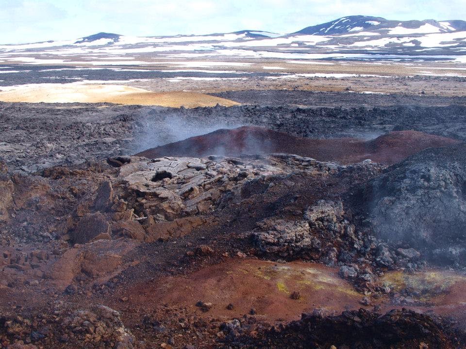
View from Stora Viti towards the Leirhnjukur area. It is a lavaflow from a 1984 eruption and the area is still very much alive with fumaroles, and springs. But it is a dangerous area. In many places the surface crust is so thin one risk falling trough-to boiling conditions. The area is formally closed off-but lot of people-I was one of them-still go. The place is great, but there is personal risk to it.
Fried ground at Leirhnjukur, part of the Kraflacaldera. The person on the picture had no idea what he was doing, he went all the way up to the mustard coloured ground 2 centimeters above his head. That kind of colour is a sharp warning sign in a place where things are going on just below the surface. It is an area of colours-black lava with stripes of white snow. White steam rising towards a blue sky. Brownish, yellowish and whitish shades around the fumaroles (gas vents). A few pools reflecting the colours of their surroundings. And even tiny specks of flowers.

Leirhnjukur


Hissing ground.


The pseudocraters at Skutustadir at the southern part of the lake. They offer a nice half hour hike. Pseudocraters are sort of fake craters-no lava ever emerged from them. They are formed by steam explosions, the steam formed by lava passing over moist ground. Some of the tiny craters are formed by volcanic bombs-glowing rocks flying trough the air-which buried themselves into moist ground when they landed.


Cowshed Cafe, a place neighbouring a cowshed.

Grjotagja a small cave near Reykjahlid. It is filled with warm water. For decades it was a fave bathing spot, But for several years, the water has been to hot for that. However, it was cool enough to allow a footbath when I visited.